Manni Kirchner Collection Archives and information belonging or researched to Manni Kirchner, containing images of finds, scans of maps, documents and uploads of personal papers written about Ropley/East Hampshire area.
Extent unknown
Place Ropley and the surrounding area
Contributor Manni Kirchner
Language English
Reference number ROP/003
License Creative Commons Attribution-NonCommercial-NoDerivs (CC-BY-NC-ND) Records in this Collection Commemorative Brass as thanks to Marianna Hagen's Payments to repair St. Peters Church. The text reads: "TO COMMEMORATE THE GIFT OF MARIANNA SOPHIA HAGEN FOR THE RESTORATION OF THE CHURCH BELLS AND THE PROVISION OF A NEW TREBLE BELL. THIS BRASS IS __________ GRATEFUL PARISHIONERS 1927" (ROP/003/001)
This Document written by TF Kirby in 1902 for the Society of Antiquaries is one of the most vital resources to researching Ropley, it is a fascinating piece of historical research. It details and preserves a lot about the parish and neighboring areas focusing primarily on the medieval to post medieval era. The document has come into ... (ROP/003/002)
1964 map of Four Marks 1:25000. With Kind Permission from Ordnance Survey. Sheet SU63 including Four Marks, Ropley, Bishop's Sutton, Bighton, Medstead, Chawton, Wield, Old Alresford (ROP/003/003)
1962 1:10560 Map of Four Marks. SU63 SE interestingly this map has a abnormally high scale, almost 1.5x as detailed as a typical 1:25000 OS map. With Kind permission from Ordnance Survey (ROP/003/004)
Transcription of the Tithe Map Awards that are an accompaniment to the 1839 Ropley Tithe Map. This useful transcription lists all field, lane and pond name in Ropley, their tenants and/or Landowner's. The original awards hold also details rent charges etc. The original Tithe Map and Awards are held at the Hampshire Records Office (HRO). Images ... (ROP/003/006)
1743 Map made for no known purpose. Displays field names, acreage and scale. The maps orientation has south to the top of the map, to have the north at the top of the map rotate the map 180 degrees. Held in Winchester College archives. (ROP/003/011)
Map of Farringdon made in 1747, including modern day Four Marks. The map was made for the purpose of visualising the enclosing of Farringdon common in the 1740s. Note the map is oriented with west to the north, turn the map 90 degrees left to have north at the top. (ROP/003/012)
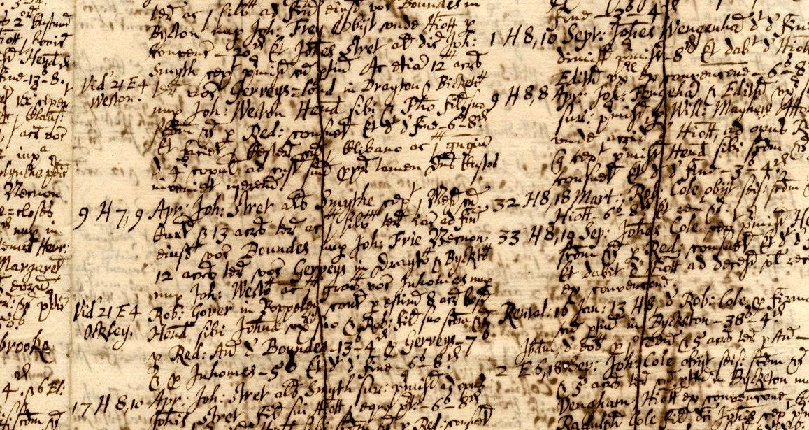
These Court Rolls detail land possession and transactions of Ropley, and some parts of Bishop's Sutton, Bighton and Medstead from the medieval period to early 1700s. These are vital resources that detail place and field names, families and the ownership of the manor Ropley by Winchester College. These documents were scanned at the request of Manni ... (ROP/003/013)
Reproduction and Tracing of a post 1750 map of Upper Chawton Park from the Hampshire Records Office Ref: 39M89/E/B262/1. (ROP/003/014)
")


No Comments
Add a comment about this page