The route of the Pilgrims’ Way from Winchester to Canterbury has always been an interesting subject about which there is a great diversity of opinion.
In Chaucer’s day there was of course no road system as there is today, and transport was by horse, ass, cart or on foot. Even carriages did not exist. From earliest times long journeys were made over ridgeways, or people followed cattle droves or narrow bridleways or footpaths. These were created by continual passage over the years across otherwise virgin ground.
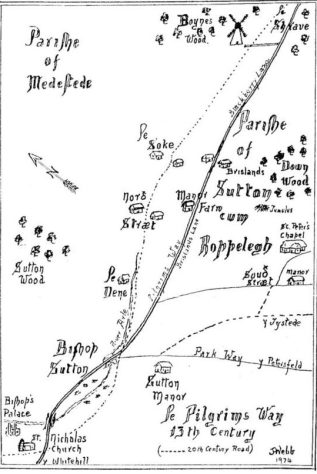
The Pilgrims’ Way (map by J.A.L.Webb)
In The Pilgrimage to Canterbury by Henry Fearon, the author describes a route from Winchester via the Worthies to Old Alresford Wield and Medstead to Alton. On this road one would probably call in for sanctuary and refreshment at the Chapel at Godsfield near Lanham, where there was a Chapel of Ease maintained by the Knights Hospitallers of St John. This chapel has in recent times been used as a grain store on Godsfield Farm, but it still retains its original form with an apse, lancet windows and original low-arched doorway. Another chapel still exists in use at North Baddesley. This was originally built for the Knights Templars but was later taken over by the Knights of St John, who still hold the deeds.
Other writers, notably Hilaire Belloc, describe a route through Ropley, and in his book The Old Road (quoted at some length in Marianna Hagen’s book Annals of Old Ropley) Belloc says archaeological discoveries mark the whole road. Belloc’s route goes by way of Whitehill to Bishop’s Sutton, then by way of the Dean to the Anchor Inn at Ropley, then follows Hook Lane, across the grounds of Ropley House, behind the Chequers Inn, to Brislands Lane by the Manor Farm House. There we follow Belloc’s route to Four Marks, where at the junction with Lymington Bottom stands a cottage that used to bear the name of “Pilgrims” (later renamed Keepsake Cottage). Brislands Lane was until recently still known by some of the older residents as the Pilgrims’ Way. The Way then followed Blackberry Lane towards Chawton.
But the Ropley route, if indeed it was a pilgrims’ route, must surely be only one of many and the probable conclusion is that there never was any definitive Pilgrims’ Way as such. Pilgrims would use tracks and routes already in existence; and just as present day hikers plan their journey from day to day, so it seems did those pilgrims dependent upon the vagaries of the weather and rumours they would hear of footpads and other hazards on the way.
The Pilgrims’ Way (map by J.A.L.Webb)
The route of the Pilgrims’ Way from Winchester to Canterbury has always been an interesting subject about which there is a great diversity of opinion.
In Chaucer’s day there was of course no road system as there is today, and transport was by horse, ass, cart or on foot. Even carriages did not exist. From earliest times long journeys were made over ridgeways, or people followed cattle droves or narrow bridleways or footpaths. These were created by continual passage over the years across otherwise virgin ground.
In The Pilgrimage to Canterbury by Henry Fearon, the author describes a route from Winchester via the Worthies to Old Alresford Wield and Medstead to Alton. On this road one would probably call in for sanctuary and refreshment at the Chapel at Godsfield near Lanham, where there was a Chapel of Ease maintained by the Knights Hospitallers of St John. This chapel has in recent times been used as a grain store on Godsfield Farm, but it still retains its original form with an apse, lancet windows and original low-arched doorway. Another chapel still exists in use at North Baddesley. This was originally built for the Knights Templars but was later taken over by the Knights of St John, who still hold the deeds.
Other writers, notably Hilaire Belloc, describe a route through Ropley, and in his book The Old Road (quoted at some length in Marianna Hagen’s book Annals of Old Ropley) Belloc says archaeological discoveries mark the whole road. Belloc’s route goes by way of Whitehill to Bishop’s Sutton, then by way of the Dean to the Anchor Inn at Ropley, then follows Hook Lane, across the grounds of Ropley House, behind the Chequers Inn, to Brislands Lane by the Manor Farm House. There we follow Belloc’s route to Four Marks, where at the junction with Lymington Bottom stands a cottage that used to bear the name of “Pilgrims” (later renamed Keepsake Cottage). Brislands Lane was until recently still known by some of the older residents as the Pilgrims’ Way. The Way then followed Blackberry Lane towards Chawton.
But the Ropley route, if indeed it was a pilgrims’ route, must surely be only one of many and the probable conclusion is that there never was any definitive Pilgrims’ Way as such. Pilgrims would use tracks and routes already in existence; and just as present day hikers plan their journey from day to day, so it seems did those pilgrims dependent upon the vagaries of the weather and rumours they would hear of footpads and other hazards on the way.


No Comments
Add a comment about this page