Historic Maps of Ropley and the surrounding area
This post contains links to a selection of local maps through the ages either available from this website or provided as links to external resources.
Remember to type into Search – Map and Maps!
1. Old Hampshire maps website contains various maps of Hampshire including Ropley and the surrounding area dating from 1575. Early 1 inch maps from the 1700s are also available here.
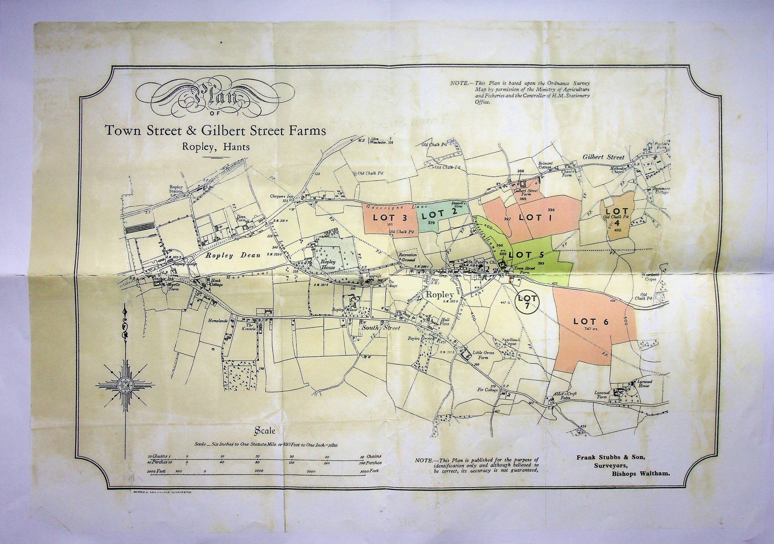
2. Various old estate maps from sale of land documents for example the document including a map from 1934 covering the sale of Town Street and Gilbert Street farms
3. Enclosure maps
Although Ropley was the first parish to have its commons enclosed by act of parliament for which a map was often commissioned there is no surviving map and likely never was. There are a limited number of enclosure maps from the area, which visualise the enclosing of land that took place from 1703 to the 1800s.
Farringdon and East Tisted both have maps from the 1740s available on our archive, although in the case of East Tisted it was not made for the purpose of enclosure. Neither maps include parts of Ropley but are nevertheless important for the local history and research, and in the case of Farringdon the majority of the area shown on the map is now part of modern day Four Marks.
4. An 18th Century Old Map of Hampshire (1724), by the German cartographer Herman Moll
5. 1808 Strip Map – Alresford to Winchester
Strip maps are linear route-maps that one follows along a strip, with key landmarks, features, and times it takes to travel between points. John Ogilby (1600-1676), (probably at least a half-brother to James Ogilvy, 1st Earl of Airlie) was an enterprising Mapmaker and Entrepreneur, he was the first to draw up a complete strip map of the UK. Ogilby issued his atlas, which he titled Britannia, in 1675 in the form of a strip map for each major route, he surveyed over 23,000 miles of highway. The work contains 100 strip road maps that are accompanied by a double-sided page of text giving additional advice for the map’s use, and notes on the towns shown and the pronunciations of their names. The roads were measured using statute mile a surveyor’s wheel, which Ogilby called his “way-wiser”, and were plotted at one inch to the– a scale of 1:63,360 – an Ogilby innovation. The maps include details such as the configurations of hills, bridges and ferries, and the relative sizes of towns, all drawn to scale. Ogilby is noted in cartography for these innovations.
He was commissioned to produce three volumes of road maps but completed only one before his death in 1676, and created the most significant of the designated post roads in a pre-turnpike era. Each of the 100 plates measures 32 x 47 cms, so hardly portable for travellers.
The strip map displayed here is dated 1808 and was drawn up by cartographer Edward Mogg, it is a hand coloured antique road strip map from Alresford to Winchester
Further information on Eward Mogg and his map making can be found at https://www.antiquemaps.com/roadmaps/mogg/index.php
6. G & J Cary’s New Map of England series 1823 Sheet 19 covering northern Hampshire and parts of Berkshire & Surrey. G & J Carey 1823 map
This is a Linen-backed folding hand coloured map, 26 x 21 inches when unfolded, with a scale of half-inch to 1 mile and degrees Latitude west of Greenwich marked. The map is labelled as “London; Published by G & J. Cary, 86 St. James’s Street June 3rd 1823”.
If you would like to see the map in more detail we have scanned the 4 separate segments of the map in higher definition, then can be found here;
Carey Map South West segment (incl Ropley)
The main coaching routes along the A4, A30, A31 & A3 are highlighted in Blue with miles from London marked at major coaching towns: Farnham, Alton, Alresford & Winchester on the A31. Milestones are counted between such towns again counting away from London. The roads around the Ropley area reflect with a degree of accuracy most of those known today but do include at least one extra link between Petersfield Road near Smugglers Lane and Lyeway Lane which is not extant today.
John Cary founded a family business which produced a large number of maps, charts and globes. His first premises were at 188 Strand (1783-1787) moving to 181 Strand in 1791 for a period of nearly thirty years before moving following a fire to 86 St. James’s Street, London (1820 – 1832) His cartographic abilities brought him a special commission in 1794 from the Postmaster-General to survey the roads of Great Britain. He is perhaps best known for the important English county atlases he produced. Cary’s New and Correct English Atlas which was first published in 1787 but which went into a number of editions in succeeding years. His maps became a reference for the golden age of coaching
7. 1839 Tithe map and Awards of Ropley – a very important map and record for our local history which gives the names of each field, landowner and tenant amongst other details.
8. Historic Ordinance Survey maps of Ropley
- 8.1 OS map of Ropley and surrounding area from the 1870s
- 8.2 OS map of Ropley and surrounding area 1891 – 1912
- 8.3 OS map of Ropley and surrounding area 1912 – 1939
Britain’s ordinance survey mapping agency has its roots in military strategy: mapping the Scottish Highlands following rebellion in 1745. This along with fears of invasion following the French Revolution caused the government to order its defence ministry of the time – the Board of Ordnance – to begin a survey of Scotland and England’s vulnerable southern coasts. Until then, maps had lacked the detail required for moving troops and planning campaigns. This initial work paved the way for modern surveying and the strategic importance of accurate maps was understood. By 1790’s a national survey for Britain was almost within reach. The first Ordnance Survey map was published in 1801. England’s most south-easterly county, Kent, was one area most vulnerable to French invasion. The name ordinance Survey wasn’t used till 1801 and not printed on a map until the 1810 ‘Ordnance Survey of the Isle of Wight and part of Hampshire’.
The first maps were available to the public in the late Georgian era. These stunning ‘works of art’ weren’t cheap, but the owner was privy to a spectacular aerial view of the landscape until then only seen from a hot air balloon. Four years later, a map of Essex followed. Within 20 years, about a third of England and Wales had been mapped at the one inch scale under the direction of William Mudge.
It was thought that 50 years would be long enough to map the country, but the entire first series of maps wasn’t published until 1870.
9. 1905/06 Ordinance Survey maps
10. 1962 OS map of Four Marks– This map and another from 1964 show the emergence of early Four Marks and the bungalows lining the A31 are still visible.
Other map resources
National Library of Scotland contains maps through the years/century’s This site enables you to view a current and historic map of the same area simultaneously
ARCHI maps UK is a database of more than 200,000 British Archaeological Sites covering the whole of England, Scotland and Wales. It is regularly updated with 10,000 new additions made to the database every year. In 2021 Archi added to their website the earliest versions of Ordnance Survey 1 inch to 1 mile maps to the ARCHI system. The maps date between 1806-1840 and really give you an insight into the period just before the Industrial Revolution made such fundamental changes to the once agrarian society of this country. Free for anyone to use
The Church of England Record Centre at Lambeth Palace
Lambeth Palace Library is the historic library of the Archbishops of Canterbury and preserves the national archives of the Church of England.
https://oldhampshiremapped.org.uk/hantsmap/grnwood2/GRW64.htm


Comments about this page
We will hopefully be doing an article about it in the near future. But there is a new book out called Ropley’s Legacy but Dr Chris Heal that is very informative about Ropley’s connection to the Enclosure Act. On sale locally and online
Add a comment about this page